Saturday
September 12, 2015
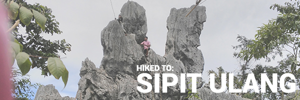
After hearing of a newly-opened mountain in the nearby province of Rizal, my officemates and I quickly set a date to hike it. This mountain is known as Mt. Sipit Ulang, and unknowingly, it has become my most technical climb to date. Let’s find out why.
Mt. Sipit Ulang (252masl) aka the Crab Mountain, is located in Brgy. Mascap, Rizal. It is called as such because of the huge rock monolith that marks the summit, which looks like the sipit (claws) of the ulang (crab).
Our assembly point was Sta. Lucia mall along Marcos Highway. After meeting up with the rest of the group, we took a Montalban-bound jeep and rode it until the Total Gas Station at San Raphael. There, we waited for one more member before riding a trike to Brgy. Mascap. The ride was a constant climb and you will be treated to views of multiple mountains along the way. Sadly some of the mountains have been victimized by quarrying and are under a state of ruin.
Anyway, as soon as we arrived at the Brgy hall, we immediately secured our guides and started the trek. The original plan was to do a traverse to Mt. Ayaas, but the guide informed us that there won’t be enough time since we already arrived late. So we decided to do Mt. Sipit Ulang alone and the side trip to Parayan Falls afterwards.

So of we went! After a few minutes of walking, we had our first river crossing!

Okay, it wasn’t that deep, only reaching up to our ankles. You can either cross on your own, or have the guide carry you across.
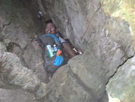
Then came the hardest part.
Caves! So many tight caves! I’ll let the pictures do the talking:

After a few caves, there was a rest stop where we took time to recuperate. Then we crossed some bamboo bridges and scrambled up some more rocks. And again, some more caves. This was the hardest part for me because I brought such a huge bag and sometimes it just wouldn’t fit. Sometimes, I had to leave the bag behind and get it later, or push it through the hole first.


Because we had some first time hikers, we climbed at a beginner’s pace, occasionally stopping for rest and for taking pictures. We were met other groups on the trail and made friends with them.


Then, we reached a cave with a large, 17-rung bamboo ladder that can only be ascended one at a time. Again, the space was really tight so I had to really squeeze in.

After that, there was another rest stop, this time, with a smaller rock formation that we can climb around and play with.


Then, you guessed it, more caves.

We reached a small clearing with a huge balete tree that locals say have supernatural powers. It did give of some eerie vibes and we didn’t stay long around it.
Past the tree, it was a final assault to the summit. There were no more caves, thankfully, just a steady hike like normal mountains.

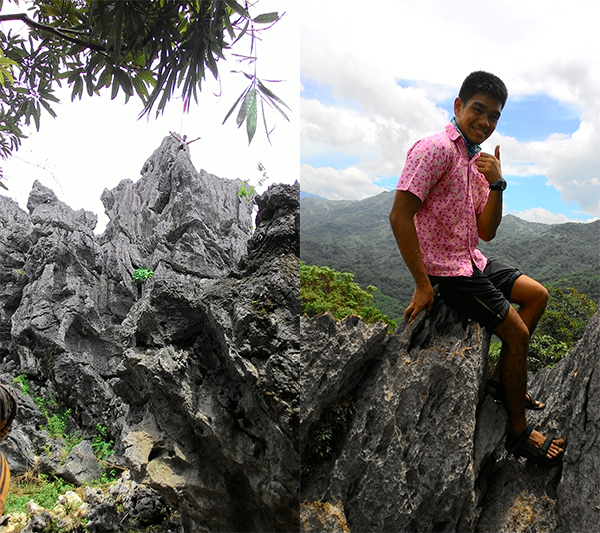
Finally, we reached the summit where the huge rock formation which gave the mountain its name stood. Because I was excited, I immediately climbed the rocks.

Needless to say, there were lots of pictures.


Unfortunately, there wasn’t any breeze at the summit, and it was getting hotter as it approached noon. So we finally decided to descend and have lunch back at the brgy.
The descent was through a different trail and was much easier. Despite the muddy ground, we reached the jump-off in about an hour, compared to our ascent which took almost four hours!
After having lunch, we took the side-trip to the 7-layered Payaran Falls. It was a trek that started the same as the way to Puray Falls, but branched out into a slight ascent before reaching the lagoon. The way was a lot of river crossings, some with the water level reaching up to our thighs.


Finally, we reached the falls, but it started to rain so we didn’t get to reach the top tier of the falls. Sad, but safety was first concern because when it rains hard, there can be a water surge and the water level did increase quickly so it was a bit scary. We stayed at the first level and just took pictures.


When we were done with the pictures, we finally went back to the brgy. to fix up and say goodbye to our newfound friends. Going back home was just reversing the process. There were many trikes waiting for passengers just outside the brgy. hall. I was so tired that I fell asleep on the back of the trike. Good thing my reflexes prevented me from falling off.
After reaching home, I promptly fixed my things and fell on my bed.
Itinerary and cost breakdown:
(Timekeeping brought to you by rosnof.wordpress.com)
- 04:14 ETD Sta. Lucia Mall, Jeep to Montalban
- P35 per head
- 04:55 ETA San Raphael Total Gas Station, secure trike to Brgy. Mascap
- 05:10 Trike ride out
- P150 per trike
- 05:40 ETA Brgy. Mascap, Registration
- P50 registration fee
- P400 guide fee for up to 5 people
- P5 Wiwi
- 06:05 Start Trek to Mt. Sipit Ulang
- 07:00 Rest stop 1
- 08:23 Rest Stop 2
- 10:40 ETA Summit, Photo Ops
- 11:42 ETD Summit
- 12:50 Back to concrete road of Brgy. Mascap
- 13:05 Lunch
- 13:47 Start Trek to Parayan Falls
- 15:30 ETA Parayan Falls
- 16:15 ETA Brgy. Mascap, Fix Up
- P5 Wiwi
- 16:41 ETD Brgy. Mascap, Trike to Total Gas Station
- P150 per trike
- 17:11 ETA Total Gas Station, Jeep to Cubao
- P28 to LRT Santolan Station
- 18:30 ETA House
Total Cost: P323
Safe Budget: P500 per head
Tips:
- Don’t bring a big bag! The caves are going to make you regret bringing anything bigger than your head. Some of the hikers that passed us brought nothing but their water bottles. So prepare accordingly and make the essentials fit in a small bag.
-

Seriously, it is this tight in the caves so don’t bring a big bag - Just like in Pamitinan and Binacayan, the rocks are sharp (even sharper). So I advise wearing appropriate protection like gloves and shoes with sturdy and thick soles.
- If all else fails and you get injured, bring a pair of band-aids or a first aid kit.
- There’s no water source along the whole trail so bring hydration. I recommend at least 2 liters but I’m a human sponge so adjust according to your needs.
- There are mosquitoes, bees, and other bugs along the trail so if you don’t like that, use insect-repellent.
For securing guides or setting up a schedule, contact the hike-master, Sir Mark Nicasio at 0905-382-6633
This hike was a new experience for me. While most mountains get me tired by slowly sapping away my energy with the assaults, I didn’t get too tired climbing this mountain. But it was still a very difficult climb. Maneuvering through the caves and calculating every step because of the slippery ground and sharp rocks made this climb very technical. It’s not a walk in the park, literally.

Kudos to my officemates who did this mountain as their first climb! Yes it can be very traumatic, but please don’t stop climbing. There are other mountains that aren’t as difficult, I promise! Thank you for accompanying me, and thank God for the accommodating weather.

And thank you to our newfound friends, the “Paang Layas Mountaineers.” It was nice meeting you. See you on future climbs!
And that’s mountain #10 conquered!

-jgzn

Sobrang harkor, walang gloves! Haha congrats on your 10th!
LikeLike
Haha got used to the pain during my Pamitinan-Binacayan hike! My hands are manhid na. Thank you! :)
LikeLike
Delikado po ba?
LikeLike
Hi! It’s a bit dangerous because if you slip, you might get cut by the rocks. So, it is a bit riskier than other mountains. Pero pag bawat apak mo sigurado naman, kaya. Triple ingat lang po. :)
LikeLike
very helpful blog for those who are planning to do a dayhike to Mt. Sipit Ulang. thank you for sharing.
LikeLiked by 1 person
Thank you for reading! :)
LikeLike
Nice info here. Thanks for this article
LikeLike