
Thursday
November 19, 2015
Words can’t express how happy I am with this climb. This has always been a goal climb of mine and after achieving it, I wanna keep coming back. Here are the nitty-gritty details of my Tarak ridge (1,130+) dayhike.
This was supposed to happen on the 18th, at the start of the APEC holiday. But with no companion to go with and no budget for a solo hike, I had to postpone. Fortunately, the stars aligned and my karma was good. I saw a friend set a hike on the 19th and I immediately expressed my interest to join their climb.
I packed my bag extra heavily for this climb because I wanted to get accustomed to carrying a heavy load for my Mt. Pulag hike at the end of the month. Lots of water, lots of clothes, and food were carried. After packing and a quick nap, I was on my way to Cubao.

I met up with my friend and her friends at the Five Star Bus Terminal. From there we boarded the Bataan Transit bus. I fell asleep through most of the travel until the conductor woke us up five minutes away from Brgy. Alas-asin, Tarak’s jumpoff.

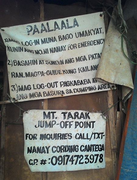
From the highway, we had a quick breakfast, coffee, and I got my morning poop in as well. After registering at the Brgy. hall and securing (waking up) a guide, we were on our way.

The trek started on a cemented road which ended with a long, rough trail leading to Nanay Cording’s house where we registered and gave a donation.

After that, it was a straightforward trek alternating through forest trails and open talahib trails. Depending on your pace, an hour and a half to two hours later, you’ll be at the Papaya river campsite.
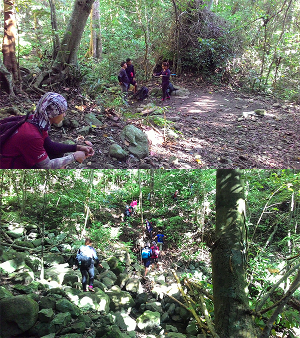
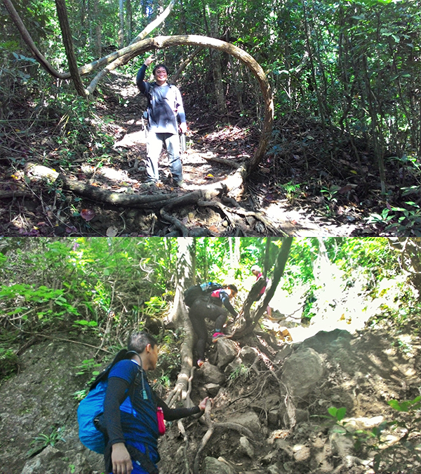
After a short breather, the trail increases in steepness as we exited the campsite and climbed through more forest trails. A bit further and we entered “4×4” territory, named as such because most people use all four limbs to climb up the steep incline covered in tree roots, vines, and loose soil.
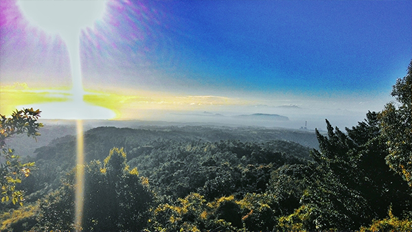
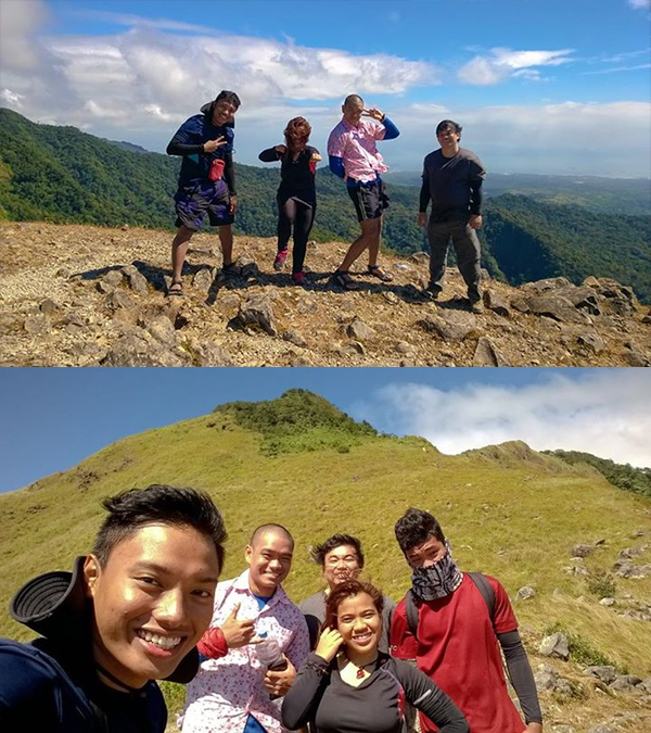
About an hour or so of assault, we emerged into an open grassland which is just a few minutes away from the ridge itself. Woohoo! All the tiredness and fatigue immediately disappeared once I caught a glimpse of this natural wonder.

You know when you’re at the ridge when the cool wind hits your body and you are almost swept away. It’s like having hundreds of industrial fans pointed at you. All the sweat from our clothes dissipated almost instantly, and even just holding our phones had the danger of them being blown away.
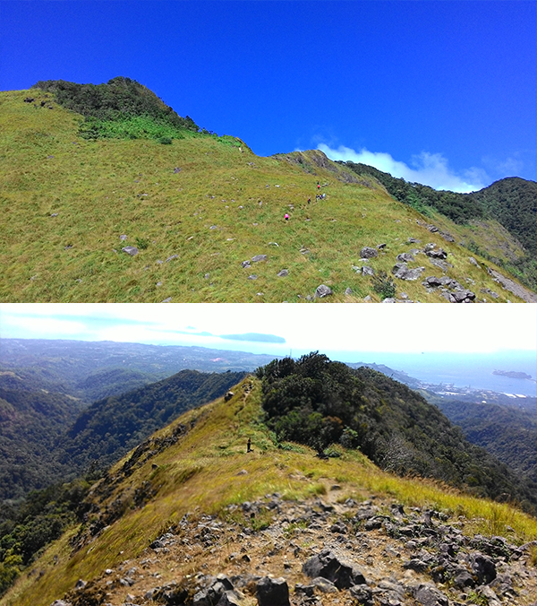
I was taken aback by the beauty. Words and pictures cannot express how awesome it was up there. I was in love. I was smiling nonstop, even as the wind battered against every fiber of my body.


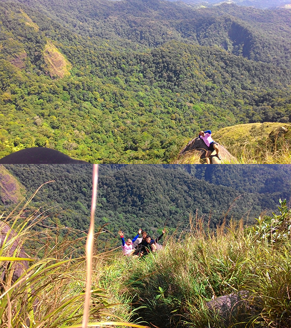
We decided to assault the summit before having lunch at the ridge campsite. The summit was another steady climb, reminiscent of the summit assault of Mt. Talamitam. There was also a short forest section where we had to use trees and roots to pull us up. From there, we reached the world tree that marked the peak.
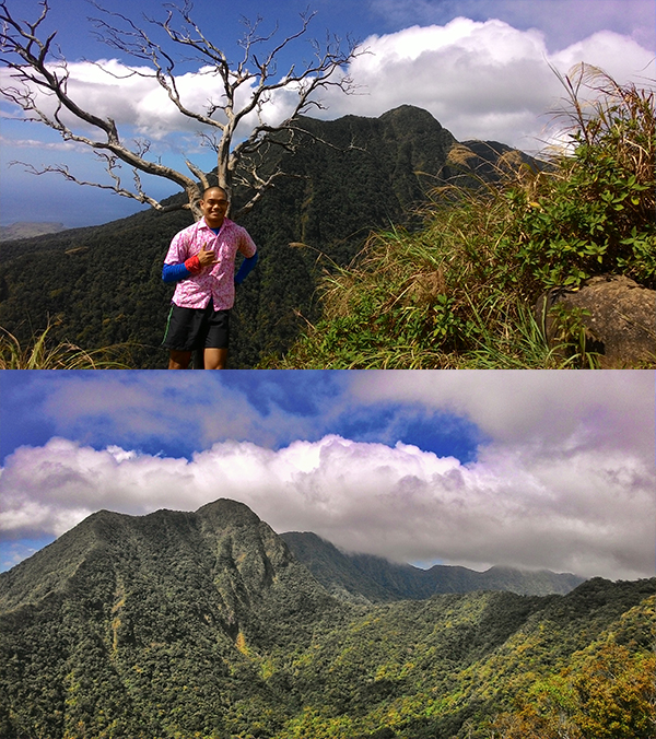
The summit was further explored. We decided not to climb up the second peak because we were running out of time. We decided to come back for it next time. Fine with me, I’d love to come back again (and again and again).
We descended after some time to have lunch and catch a quick nap. After that, we started the descent.
Going down was a lot faster. One just needs a quick step and careful foot-positioning to quickly go down the trails.
After reaching the Papaya campsite, my friends had a quick bath at the Papaya falls, while I got some shuteye (sandal-tulog).

We double-timed our pace as we had to reach the highway before 18:00, when the last bus bound for Cubao passes by. We reached Nanay Cording’s house and logged out of her record book. I also had two glasses of buko juice.

Because we were close to the cutoff time, we decided to take a trike back to the highway. We had the trike pass by a liguan to change, and then straight to the karinderyas beside the highway for a quick bite before boarding a bus bound for Cubao.
Itinerary and cost breakdown:
- 02:15 ETD Cubao, Bus bound for Mariveles, Bataan (Bataan Transit or Genesis Bus)
- P267 per head
- 04:40 ETA Brgy. Alas-asin, Register and secure guides
- P40 per head, registration fee
- P200 per head, guide fee (no fixed rate)
- 05:45 Start Trek
- 06:20 Nanay Cording’s house, register and donate
- P10 donation (no fixed rate)
- 08:15 Papaya river, rest
- 08:29 Resume trek
- 10:10 ETA Tarak Ridge
- 11:07 ETA Summit
- 12:01 ETA Ridge campsite, lunch and nap
- 13:16 ETD Ridge campsite, start descent
- 14:14 Papaya falls, bath and rest
- 14:54 Resume trek
- 16:20 ETA Nanay Cording’s house, log out and refresh
- P15 Buko juice
- 16:35 ETD Nanay Cording’s house
- P150 Trike to highway
- 17:10 Liguan, fix up
- P20 per head, bath
- 17:30 ETA Brgy. Alas-asin
- 17:45 ETD Brgy. Alas-asin, Bus bound for Cubao
- P267 per head
- 21:15 ETA Cubao
Total Cost: P884
Safe Budget: P1,000
Tips:
- Papaya river is the last water source before the ridge and the summit, so prepare accordingly.
- Prepare for very strong winds at the ridge. It can also get very cold in the afternoon. Bring necessary tents and gear.
- I would not recommend a dayhike for newbies or hikers with slow pacing. Unless you start very early or do an overnight hike, it might be hard to fully explore the ridge and the peaks and have enough time to return to the highway before 18:00.
- Expect to spend 10-12 hours on the trail. The journey is long and rough, but I promise you, it is worth it!
Our guide was Jomar, a 17 year-old who was quiet and very quick to climb up the trail. I forgot to take his contact number, so here is my friend’s guide, Kuya Bernie’s contacts: 0919 811 4849.
This is my first major climb as well as my first 1,000+ masl mountain. I loved this hike despite it being hard on the legs, and my climb-mates also agreed that this was one of the most enjoyable climbs they had.
I still recommend Mt. Batulao for newbie hikers, but Tarak Ridge is now my new favorite climb (Oh Batulao, you’ve changed. As much as I want to climb you, the required guides and excessive guide fee are such deal-breakers). I can’t wait to return! This is the kinda mountain where you haven’t even left but you already know you wanna come back to it.
Thank you to Jona (who I’ve climbed with in Hapunang-banoi) for allowing me to come with them on their climb. Thank you Neme and Alex as well for being so welcoming and taking pictures. Looking forward to the next climb with you guys! And as always, thanks to the Big Guy for perfect weather conditions and for finally making this climb come into fruition.
And that’s the beautifully, wonderful, and awesome Tarak ridge, done!

-jgzn
p.s.
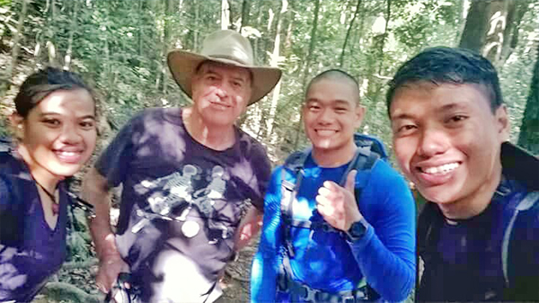
The actual reason for this climb was to see Gerald Anderson, who happened to be in Tarak as well. He passed by us on his descent as we were ascending. We couldn’t take a picture with him because he seemed to be in a rush, but we got one with his super friendly dad!

Wow ang ganda! Congratulations!
LikeLike
Hihi thank you! waiting for your Mt. Marami post!
LikeLike
was really looking for an updated story about Tarak Ridge, thanks for sharing again! We’ll be climbing in Dec. Praying for a good weather.
LikeLike
Thanks for reading, KC! If you have any questions feel free to hit me up. Have a nice hike and yes, I hope it’ll be good weather until the end of the year! :)
LikeLiked by 1 person