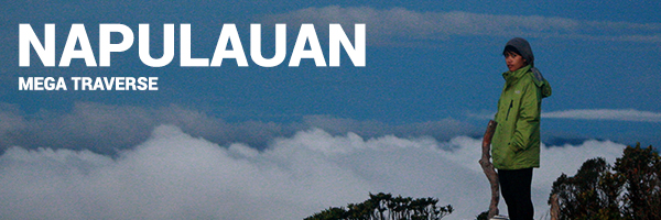
Saturday to Sunday
May 20-21, 2017
Mt. Napulauan is a familiar mountain because my friends have hiked it before. Aside from that and it being very far from Manila, I didn’t know much about it. So when Khat told me that we’ll be hiking it, I had no idea what was in store.
The initial plan was for just the two of us to climb the mountain, but then two of Khat’s friends tagged along plus another two that the coordinator at Hungduan referred to us. So from two people, our group was now six who will be traversing the mountain over the weekend. Khat, who has already climbed the mountain before, took care of all the logistics.
The group met up at Ohayami bus station in Sampaloc and we boarded with our pre-bought tickets. The bus left promptly and I braced myself for the 10-hour journey. I awoke as the bus reached the terminal of Banaue in the morning of the next day. We met up with another group doing a dayhike and we boarded a chartered van bound for Hungduan. The reason why we coordinated with as many people as possible is to save money for the van, which was the most expensive part of the whole hike.

After about an hour, the van dropped us off at a registration area and then proceeded to the jumpoff. Here, we secured our guide, tatay Ben, the father of the coordinator of Napulauan. After some last minute packing and adjusting of our belongings, we finally started the hike.

The first part of the hike was through locals trails that eventually gave way to some open grassland. I thought it was going to be just like hiking Mt. Ugo. I was so wrong. After a while we entered the forest area and the gradual uphills gave way to steep assaults. My back already started to hurt because it has been a while since I hiked with a full pack. Still, we carried on as a group and slowly but surely we ascended.
After a couple of hours, we reached Ny-o campsite where we took a bit of time to recuperate. Pretty much all of us were already tired and we haven’t even reached a third of the distance to the summit yet. After some more hiking, we decided to have light lunch before continuing.
A few minutes more and we reached the water source. We replenished our bottles but this was still a long way from the top. But finally the trails started to turn mossy and ferny and here was our biggest challenge yet. Mt. Napulauan is famous for its limatiks or blood leeches. I had already endured the heat of the day just to protect my whole body from these bloodsuckers, so I wasn’t too worried. Still, we did check each other for leeches every 15 minutes or so. Every now and then I’d find a couple stuck on my leggings and I’d ask Khat to flick them away.


After we pitched our tents, I got some sleep immediately as Khat prepared dinner. After eating, we had some quick socials before the cold made its way to my bones and I entered sleep mode. I awoke in the middle of the night to pee and the others were outside waiting for the stars. They were also playing with lights and their cameras. It was too cold so I didn’t mind them much.
The fog had disappeared and I saw numerous peaks being illuminated by the night sky. It felt so peaceful and serene that it made me sleepy right away, so I shuffled back into the tent to get some shuteye. I awoke again a few hours later to raindrops hitting our tent. It was raining so going outside was out of the question. I went back to sleep.


The mountain has three known trails, Hungduan, Hapao, and Balentimol. We already came up through the Hungduan trail and this time we were going down the Balentimol one. This trail will lead us down to two waterfalls before emerging into the highway. The way down was definitely more beautiful than the way up. The mossy forest covered us completely and all the trees branched out in grotesquely beautiful ways just trying to find a spot under the sun. It was haunting but also very mesmerizing. The trail didn’t look like it was used very often and upon asking if a lot of hikers go up the mountain, tatay Ben told me it’s been about a month since he last went up here.
We continued to descend as the sounds of birds entertained us. I am sure there are still lots of animals living here as most of the mountain is still untouched. Who knows what creatures surrounded us in that forest. It felt like i was in the jungle with Naked Snake in MGS3:SE.
There were also lots of interesting flora along the trail like berries and some star-shaped flowers. Indeed, the way down was made less painful by the attractions found on the trail. Eventually, the mossy forest gave way to a trail that looked like it hadn’t been used for a while. We stopped for a bit. Khat didn’t remember this trail during her last hike so we waited for the rest of the group to arrive. In our rush to go down, we had left the rest behind so we stayed put until tatay Ben arrived and we continued on.

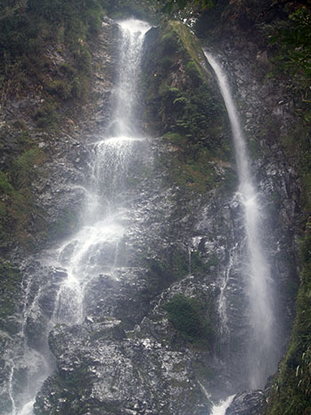
Here, we rested for a bit and I admired the many layers of the falls. We also refilled our hydration and ate some of the food leftover from breakfast. We waited for the rest of the group to arrive and after some more relaxing, we decided to push on ahead.
Again, it was back to more steep descents along cliffs and rock faces. I thought I was gonna slip, fall, and die. The same went for Khat, who I was following down the trail. The reason why she didn’t remember the trail much was that it wasn’t this wild last year. She said that the trail was well-groomed and not this dangerous when they crossed. We expressed our hardships with the trail and continued to go down. At times, my knees and legs were shaking already. We also spent some time removing limatiks as they were more aggressive in this side of the mountain.
After some more descents through loose rocks and a pine forest, we reached Balentimol falls. I was glad because this meant that we were almost near the exit point. We took a bath in the cold waters and also washed ourselves up. We brewed some coffee before heading down to the highway to wait for the others. Napulauan Megatraverse complete!

After an hour or two, the group was eventually completed and we rode our chartered van back to the jumpoff to drop off our guides. We said goodbye to tatay Ben and our van took us to the bus station where our bus was already waiting for us. It was another long ride back to Manila and I filled the time with sleep, knowing that I’ve just finished traversing my most difficult mountain so far.

Of course this climb wouldn’t be possible if not for the people who were with me to make it happen.
Thank you first and foremost to Khat, #MyTrailLove, for organizing the logistics and everything else. You know that this wasn’t an easy climb for me because of my sickness but you still made it enjoyable. Thank you for cooking the most delicious mountain food while i was resting and for providing warmth in the cold night. I am most thankful for you always.
I would also like to extend my gratitude to Sir Nat and Doc Daryl as well as to Shaun and James for accompanying us in this climb. Thanks Sir Nat for taking care of the rented van as well. Congratulations to all of us!
To tatay Ben for guiding us and not letting us die or get lost. It was very nice listening to your stories and we hope to see you again if ever we return.
Lastly, to the Big Guy for protecting us in this hike and for the cooperative weather and circumstances. AMDG.

Itinerary and budget breakdown:
Day 0
- 20:00 Assemble at Ohayami bus station in Sampaloc, take bus bound for Banaue (Buy tickets beforehand)
- Php490 per head
- 21:00 ETD to Banaue
Day 1
- 07:15 ETA Banaue, wait for chartered van, buy supplies, eat breakfast
- Php3,500 per van, good for 12 person
- 09:45 ETA Banaue Information Center, register
- Php50 per head, Registration fee
- 10:30 ETA Bugan’s Homestay (Jumpoff), final fix up of things, secure guide
- Php2,000 Guide fee, 1 guide:7 hikers
- 11:00 Start trek
- 13:00 Ny-o Campsite, lunch
- 14:00 Water source
- 17:35 ETA Summit, set up camp, socials
- 20:00 Lights off
Day 2
- 05:00 Wake up, wait for sunrise
- 06:30 Breakfast
- 08:10 Start descent
- 11:15 Mongkilat Falls
- 14:00 Balentimol Falls
- 15:20 Balentimol Exit
- 17:30 ETD Balentimol Exit via chartered van
- 18:45 ETA Ohayami bus station, bus to Sampaloc
- Php490 per head
Day 3
- 04:30 ETA Sampaloc
Safe Budget: Php 3,000 per head
Tips:
- Prepare for endless assaults going up to the summit via the Hungduan trail
- Prepare for endless Limatiks
- Don’t die along the Balentimol trail
This hike is my most difficult climb to date. It’s even harder than the Sicapoo climb even though Napulauan has a lower ranking according to pinoymountaineer. Goes to show that those rankings tend to be arbitrary. In the end, a mountain only has two difficulties: doable or not doable. I am glad I was able to do this one!


Climb with passion and a smile on your face.
-jgzn
P.S.
Most of the pictures here are from Daryl, Nat, Shaun, James and Khat. Here are some more pictures from the climb:


Hello Sir, baka pwede pa share naman contact number ni Tatay Ben (guide). Thank you.
LikeLike
Hello Sir, unfortunately wala kaming number ni Tatay Ben, but you can contact his daughter via FB. Just search for mam Jascel Bugan Hill. :)
LikeLike